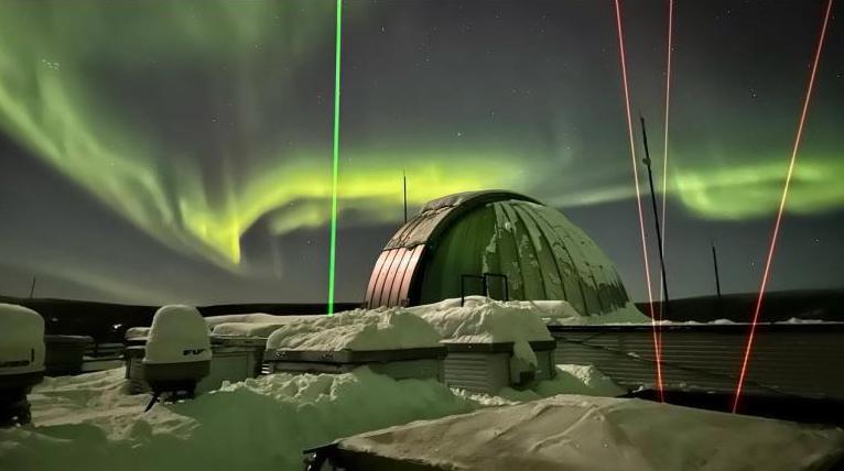
University of Alaska Fairbanks scientists are developing a new light detection and ranging instrument to help gain a better understanding of space weather enveloping Earth.
The new laser radar, or lidar, will be the third for the UAF Geophysical Institute. It will measure temperature and neutrally charged iron in the upper atmosphere at altitudes of 75 to 125 miles, where the mesosphere and thermosphere meet.
Understanding the processes and influences at that altitude has become increasingly important as the proliferation of low-Earth orbit satellites continues and more nations send probes through the region on their way to the moon and elsewhere.
“The goal is to develop a remotely operated iron lidar to complement the current science investigations with the Geophysical Institute’s two established lidars,” research assistant professor Jintai Li said.
Li leads the science operations at the Lidar Research Laboratory at Poker Flat Research Range, a unit of the Geophysical Institute. He received his Ph.D. in atmospheric sciences from UAF in 2019.
The new lidar is being developed in collaboration with a commercial laser partner and will be placed at the Geophysical Institute’s High-frequency Active Auroral Program facility near Gakona. The new lidar will support experiments at HAARP and provide complementary measurements to Poker Flat’s two lidars — the sodium resonance wind-temperature lidar and the Rayleigh density temperature lidar.
“Lidars employ laser spectroscopy to make measurements of temperatures, densities and winds in the upper atmosphere that cannot be made by other methods,” said Richard Collins, director of the Lidar Research Laboratory.
Collins is an atmospheric sciences professor and also director of the UAF Graduate School.
A lidar uses a pulsed laser beam to resolve and distinguish objects or targets at different distances within a specified range. It is similar to radar but uses light instead of radio waves.
Two types of lidar exist. One detects a hard surface and can create highly detailed 3D maps of terrain, buildings, vegetation and other objects. Another type detects the volume of a target, such as a water body or atmosphere.
With atmospheric lidars, scientists can determine wind speed and direction by analyzing the Doppler shift in the returned signals. The Doppler shift refers to the change in frequency or wavelength of a wave in relation to an observer who is moving relative to the source of the wave.
Temperature can be inferred from the broadening of spectral lines in the laser’s returned light. Broadening is caused by the thermal motion of particles. Hotter areas have faster-moving particles, resulting in broader spectral lines.
Construction on the new lidar, called the iron resonance wind-temperature lidar, began in April 2021. It is funded by a $1.4 million National Science Foundation grant and is expected to be operational later this year.
The lidar will measure neutrally charged iron atoms rather than the molecules of the atmosphere itself. The color of the lidar light is precisely tuned to give a strong echo from the iron atoms.
“The trick is to select the right laser color so that the iron atoms embedded in the air give us enough returned signal to work with,” Li said.
Meteoroids, and especially micrometeoroids, continually bombard Earth’s atmosphere and deposit iron and other elements into the mesosphere and thermosphere as they burn up at the edge of space.
While there are several metals deposited by meteors, recent studies have shown the iron layer extends to higher altitudes. This means lidar measurements can be obtained deeper into the space weather region.
At HAARP, the new lidar will help scientists study a variety of occurrences and interactions that require both radar and lidar. Among them is the interaction between dusty space plasmas and polar mesospheric clouds, also called noctilucent clouds.
Noctilucent clouds consist of tiny ice crystals and appear as thin and electric blue clouds that can sometimes be seen shining in the night sky during the summer months at high latitudes. Dusty space plasmas are regions of space where charged particles — plasma — and solid particles of dust coexist.
Dusty space plasmas can affect Earth’s upper mesosphere by introducing particles that can lead to changes in atmospheric chemistry. Changes to the mesosphere can influence the formation, distribution and duration of noctilucent clouds.


